


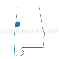
Reform Bill's Dollar Store, Pickens County, Alabama
About
Outline

Summary
| Unique Area Identifier | 522778 |
| Name | Reform Bill's Dollar Store |
| County | Pickens County |
| State | Alabama |
| Area (square miles) | 43.34 |
| Land Area (square miles) | 43.23 |
| Water Area (square miles) | 0.12 |
| % of Land Area | 99.73 |
| % of Water Area | 0.27 |
| Latitude of the Internal Point | 33.38817280 |
| Longtitude of the Internal Point | -88.05210690 |
Maps

Graphs
Select a template below for downloading or customizing gragh for Reform Bill's Dollar Store, Pickens County, Alabama


Neighbors
Neighoring Voting District (by Name) Neighboring Voting District on the Map
- Bethlehem Voting District, Pickens County, AL
- Carrollton 1 Service Center, Pickens County, AL
- Carrollton 4 Service Center, Pickens County, AL
- Liberty School, Pickens County, AL
- McShan Comm Center, Pickens County, AL
- Palmetto Community Center, Pickens County, AL
- Reform 3 Bill's Dollar, Pickens County, AL
Top 10 Neighboring County Subdivision (by Population) Neighboring County Subdivision on the Map
- Carrollton CCD, Pickens County, AL (3,840)
- Reform CCD, Pickens County, AL (3,656)
- Ethelsville CCD, Pickens County, AL (2,029)
Top 10 Neighboring Place (by Population) Neighboring Place on the Map
Top 10 Neighboring Unified School District (by Population) Neighboring Unified School District on the Map
Top 10 Neighboring State Legislative District Lower Chamber (by Population) Neighboring State Legislative District Lower Chamber on the Map
Top 10 Neighboring State Legislative District Upper Chamber (by Population) Neighboring State Legislative District Upper Chamber on the Map
Top 10 Neighboring 111th Congressional District (by Population) Neighboring 111th Congressional District on the Map
Top 10 Neighboring Census Tract (by Population) Neighboring Census Tract on the Map
- Census Tract 503, Pickens County, AL (3,840)
- Census Tract 501, Pickens County, AL (3,656)
- Census Tract 502, Pickens County, AL (2,029)